Interview conducted by a University of Alaska researcher, April 5, 2017
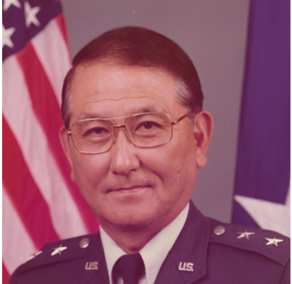
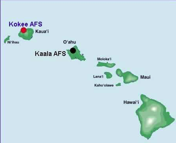
Good morning, I am Arthur Ishimoto, 94 years old. In 1949, I transferred to the Hawaii ANG from A Company, 100th Inf. Battalion, 442nd Infantry Reserve. I was involved in the development of the Hawaii Air Defense System from its inception to completion. I was the project engineer and manager. The following events began to unfold 67 years ago. (Show map to indicate unit locations)
The 109th Aircraft Control and Warning Squadron (ACW) was activated in late 1950. Its headquarters was at Battery Closson, a pre WW2 coastal battery located across the entrance to the current Hickam AFB golf course. In early 1951, it moved to Koko Crater AFS after the USAF vacated that site. This was a WW2 radar site and had the old AN/CPS-1 radar. The radar was located atop the 1200 ft hill. Access to the top was via a cable car. The operations center was located underground in a tunnel at the top. In 1956, I was hired by the 7th Air Force as project manager to install heavy ground radar and ancillary equipment for an air defense direction center at Punamano, Oahu, a former WW2 radar site. It was situated on a cliff overlooking the old Kahuku airfield runway on the north shore and Kamehameha Highway. 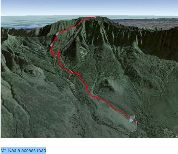 This may have been the radar site that detected the Japanese aircraft approaching Pearl Harbor on December 7, 1941. Some said this site was the Opana radar site, but others said it was another location. Description of the location of Opana radar site led me to believe that this was the Opana radar site that detected the Japanese aircraft. The following equipment were installed at Punamano: FPS-8 Search Radar TPS-10D Height Finder Radar Internal telephone system UHF air to ground radio equipment External telephone system Radar Tower
The mission of an air defense direction center is to provide air surveillance, detect all aircraft, identify it, if unknown, guide interceptor aircraft to the potential threat and to destroy it if hostile. Punamano Direction Center became a detachment of the 109th ACW Sq. At midnight July 1,1956, it began operating. There were 54 full time positions. The information from the Direction Center was transmitted to the 7th Air Force Control Center in Kunia Tunnel located adjacent to Wheeler AFB. The 326th Air Division replaced the 7th Air Force in June 1957. I was chosen the detachment commander of Punamano. Full time guardsmen were federal civil service employees and not on active duty. They were called air technician. The 169th ACW Sq was activated on October 7, 1956. Its commander was Maj. K.P. Goya a member of the 109th ACW Sq. Its headquarters was at Sand Island, Oahu. In July 1956, Pacific Air Force (PACAF) Inspector General conducted an operational readiness inspection of Punamano Air Defense Direction Center and declared it capable of fulfilling its mission. Late 1956, I was chosen by PACAF Inspector General and placed on active duty to join their team to inspect the 13th Air Force. I was the first ANG officer to inspect a regular air force unit as a member of the Inspector General’s team. We conducted an operational readiness inspection. By the way, I had two choices to go to the Philippines from Hickam AFB. One to Yokota AB Japan then to the Philippines and the other via the southern route to Eniwetok and to the Philippines. I chose the latter. The flight to Yokota vanished and all aboard were missing. Had a similar incident in WW2. I was on orders to go on a special mission, but replaced. The C-47 crashed and all was killed. Since the Punamano operation was a success, on December 1957, the 169th ACW Squadron began full-time operation as Air Defense Direction Center at Koko Crater AFS and a change of station to that location. This was the second full-time mission for HANG. Another ANG full time air defense direction center was established in Greeley Colorado. The FPS-8 radar was installed at Koko Crater AFS. Other required equipment was already in place. In 1958, I was appointed as full-time Director of Communications Electronics and based at Ft. Ruger, Oahu to guide and oversee the operation of the two full time units. The most important management tool I used was the Self Inspection System. It assured all direction centers to perform efficiently and effectively.
In 1959, the United States Air Force (USAF) planned a two site permanent air defense direction center. One was at Kalalau in the Kokee State Park, Kauai, elevation 4200 ft. The other at the top of Mt. Haleakala, Maui, elevation 10,000 ft. The total cost was $5,000,000. Since the USAF did not have the funds, they asked the National Guard Bureau (NGB) to fund and take over the project. The NGB approached HANG. It was turned down because the amount of money available was only $867,000. We were asked to reconsider. It was referred to me for review because of my expertise in communications-electronics. I said it would require a system change and equipment modification. I was given the approval to proceed but was warned that I cannot expend $867,000 unless I am positive of success. I was mindful of this, but proceeded. The success of this project was dependent on eliminating seven radio relay sites. I needed a successful point to point radio system between Kalalau, Kauai and Punamano, Oahu, a direct shot without any relays. I designed five element high gain antennas and made a minor adjustment to the receivers to improve the signal to noise ratio, essentially increasing the range of the radio. The equipment was the AN/TRC-24 FM radio, which was used by USAF. It was designed to operate 25 nautical miles at line of sight. I needed to transmit and receive signal 91 statute miles over water and not line of sight. We placed a TRC-24 at Kalalau on a flat bed truck with an adjustable height antenna. At Punamano, the equipment was installed above a WW2 bunker. We moved the equipment around the Kalalau site to seek an optimum location. We found it and raised and lowered the antenna and found the optimum height.
We ran a test for four months to determine whether the refractive and reflective component present in the atmosphere would attenuate the signal. We recorded the signal on a paper tape recorder something similar to recording an earthquake on a Richter scale. The tape showed the signal strength and fluctuation. We also kept a record of temperature, wind speed and humidity level. These affect refraction and reflection of radio signals. After 4 months of continuous recording, I decided the system was reliable. The test showed 99.99% reliability. Elimination of the 7 radio relay stations saved millions of dollars in infrastructures, especially access roads and power lines. To coin a phrase, “We squeezed blood out of a turnip”. When I first visited the Kalalau, Kokee site, there was nothing there, just bushes and trees like those in the surrounding area, no water no electricity. It was a large area around 2 acres. 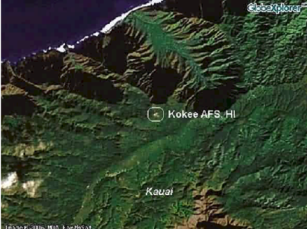 It was located adjacent to Kalalau Lookout, a popular tourist attraction. It gave a nearly 360 degree view except to the east where Mt. Waialeale blocked the view a few degrees. There was no sign of wildlife at the site. I did not anticipate Haleakala to be a problem. It was an ideal location at the right height, where there would be less chance of what we call “Anomalous Propagation.” It is a false echo on radar. It had a clear 360 degree view. It is normally above clouds and at low humidity. The University of Hawaii and the TV stations, who had installations at the 10,000 ft. level, objected to our proposed installation. We proved to the TV stations that there would be no interference, but University of Hawaii stood firm in their objection. A scientist with a PHD degree was strongly against our planned installation. He claimed we will ionize the atmosphere, cause dust problems and would ruin their experiments. The U of H never revealed what their experiments were. I felt they deceived us. The Air Force did not plan to remote the video to Wailuku, Maui. It was planned by me for one reason. Haleakala summit road was winding, dangerous and long with numerous sharp curves, about two and a half hour drive from the airport at Kahului, Maui located next to Wailuku. Too costly to build an operations center at the summit. I felt the cost of remote equipment can be covered from within the allotted fund, but there was a worrisome question of having enough fund for constructing a new facility. I needed to look for an existing National Guard facility to convert it to cut cost. However, the continued objection of University of Hawaii killed our project at Mt. Haleakala. As a result, the Federal Aviation Administration (FAA) proposed to us that we use Mt. Kaala on Oahu as a joint-use facility. I did a composite radar coverage diagram and sent it to PACAF for approval. It was approved.
  Moving to Mt. Kaala did not reduce the air defense detection capability because it is primarily looking east and covered the blocked area to the west by Mt. Waialeale on Kauai. The threat was from the west and the FPS-3 at Kalalau looked west. This was a blessing, because the operation center would be at Wheeler AFB. The cost to establish one can be easily supported by converting a warehouse to a direction center. I was thankful that we moved to Mt. Kaala rather than operate from Haleakala. I did, however, thought about using Mt. Kaala instead of Haleakala even before the FAA made their offer, but the cost of the road was prohibitive. Having FAA join us never entered my mind. I am forever thankful to them. We began the facility design of Kalalau, Kauai . Many of the equipment installation drawings can be used at Mt. Kaala, Oahu because they were similar equipment except for the the FPS-7. The Civil Engineering Dept. at Hickam AFB developed architectural plans based on our facility drawings. They were responsible for all the preliminary construction tests. They gave us great support. We began the engineered drawings for the installation of radars and communications equipment. I had Capt. David Dang and a Chief Msgt Walter Watanabe to assist me. We worked 7 days per week 14 hours per day for six months. In November 1959, MSgt. Watanabe and I took the engineered drawings to Ground Electronics Engineering Installation Agency, called GEEIA at Tachikawa Air Base Japan for approval. Due to several dozen drawings submitted, it took them 3 weeks to approve them. Based on our engineered drawings, the installation was accomplished by GEEIA personnel for the search and height finder radars. All communications equipment was installed by HANG personnel.
On March 7, 1961, the Hawaii Army National Guard’s 298th Artillery Group (Air Defense) began a 24 hour air defense with their Nike surface to air missile as two of ten Nike sites in the Army’s Air Defense System. They were located at Bellows Airfield and Barbers Pt. NAS. Construction of Kalalau buildings and radar tower foundations started in early 1960. The contractor was A.C. Chock. When the construction was completed, two radar towers, the AN/FPS-3 search radar and the AN/ FPS-6 height finder radar including ancillary equipment were installed.. Since no power line was available, we installed two large diesel driven power generators that supplied power continuously. Several years later, the local power company provided power to Kalalau area. I had to find a water source. A civil engineer proposed we use water catchment from rain falling on the roofs of buildings. I was against it. My research discovered that Mt. Waialeale was the wettest spot on earth with an average of 471 inches of rain per year as recorded from 1921 to 1950, which is only 10 miles from Kalalau.
 Kokee State Park had an average rainfall of 70 inches per year. I knew there was water underground. Water underground is a steady flow. Rainfall is not. With the help of a friend from National Geodetic Survey, we found a source close to the site. We drove a 3 inch pipe into the ground. At 3 foot depth, water gushed out. We took a sample and had it tested for bacteria. It was found to be pure spring water free of bacteria. I had a pump installed and ran the water line about a fifty yards to a 50,000 gallon water tank. The short run saved money in plumbing. The air defense direction center was flight tested, evaluated and declared operationally ready. In October 1961, Kalalau in the Kokee State Park and known as Kokee AFS was activated. The unit was named the 150th ACW Sq. Full time personnel from the 109th ACW Sq. relocated to Kauai. This installation and relocation boosted the economy of Kauai and fully supported by local politicians and merchants. To show the community how much the presence of 150th ACW contributed to the local economy, Captain William Mossman, its commander, paid his people in silver dollar coins and paper currency. The merchants and banks were impressed with the amount of money circulated. There was an opening ceremony with Lt. Governor Kealoha present including the mayor of Kauai, an air force representative and other dignitaries. *Break July 1956, HANG placed two F-86E fighter aircraft on runway alert. This was a day fighter only and provided sun up to sun down protection. Later, HANG converted to the F-86L an all weather fighter that can provide intercept capability 24 hours per day. It had a new fire control system including air to air missiles rather than only machine guns, which gave it the capability to fly and fight at night in all weather situation. It had the Falcon air to air guided missiles besides the other folding fin rockets and an afterburner to boot.
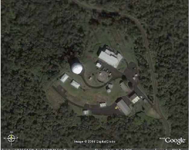
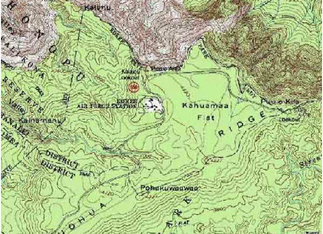
In December 1960, the first F-102 Delta Dagger fighter arrived and in March 1961 we received 20 F-102s from the Air Force coming from units in the Philippines and Okinawa. I could not find the conversion date to the F-102, but I assume it was in mid 1961. In 1976, the HANG converted to the the F-4 fighter aircraft, which had an infrared heat seeking missiles. I will mention more fighter aircraft upgrades later in this presentation. On or about 1966, I decided to modify the search radar at Kalalau at Kokee, by extending the range another 100 miles. We conducted a test for six months and sent the data to a responsible USAF agency for approval. It was approved. This was indeed a fortunate modification. When Hurricane Iwa hit Hawaii in 1982, the Geo Weather Satellite failed and no information was available on the location of the hurricane. When the hurricane approached Kauai, the radar operators at Kokee tracked the storm as soon as it appeared on their radar scopes. With that information, the State Civil Defense was able to give advance warning on the approaching storm and had businesses, schools, etc. closed. The extended range gave an additional hour of warning. The public was sent home to be prepared for the storm. No lives were lost. The facility withstood the plus 100 mph wind and minimal damage to the facility. Tracking hurricane is a slow process. It traveled about 12 mph. An air threat travels much faster, but the 100 mile extension gave air defense approximately an added 4 minutes advantage and it was significant. It moved the Minimum Intercept Line 4 miles out, which is based on interceptor speed and the radar cross section (reflectivity) of the target. The Minimum Intercept Line (MIL) is the distance where initial intercept takes place against the enemy. More on this later. Mt. Kaala, at 4026 ft. elevation, was jointly funded by FAA and HANG. FAA built the access road at a cost of $1.3 million. In today’s dollar, it would cost $9.7 million. We provided funding for site development. At Wheeler AFB, we converted Building 204 an old warehouse and made it into an Air Force/ HANG joint-use facility, thus saving a lot of money. The Air Force Control Center and the 169th Aircraft Control and Warning direction center were collocated. Collocation improved efficiency and reduced operating cost. Mt. Kaala was fraught with problems. There was a contract dispute between the contractor and the FAA. Also, construction of the 6.8 miles access road was through risky and dangerous terrain, which resulted in nearly a year to complete. A geologist discovered a potentially dangerous fault at the near top. It was later determined not to be a problem, but caused us great concern. These negative events caused a long delay. Look at the Google map that shows the access road and the steep terrain of Mt. Kaala. It will give you an idea of how treacherous the road is. We could not make a site survey of Mt. Kaala, because there was no road or trail to the top. FAA did an aerial survey first. We did a ground survey after the access road was built. It was virgin land and dangerous. Unknowingly, a person on the site survey team stepped on a hidden peat bog. He suddenly sank to the ground up to his chest. He could have disappeared. There was no sign of wildlife there, but a lot of insects especially mosquitos. At Mt. Kaala, we installed the AN/FPS-7, a 5 megawatt search radar and the AN/FPS-6 height finder, a 10 megawatt radar. 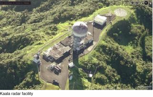
 On the internet there are several websites that gave erroneous information about the nomenclature of the radar as AN/FPS-3 and that there were two FPS-6 height finders, only one was installed. There was limited space atop Mt. Kaala. I designed an air/ground radio antenna tower paying particular attention to antenna spacing and separation of frequencies to prevent “intermodulation problem”. It is amplitude modulation of the sum and differences of two or more frequencies resulting in additional frequencies or harmonics. The road was constructed by JM Tanaka and paid for by the FAA. Construction of the road presented a formidable challenge to the contractor. The access was through a razor back ridge. While standing on the ridge, you can see the southern shores of Waianae on one side and on the other side the northern shores of Kahuku. The workers strapped themselves to a hawser for safety and used pick and shovel to widen it to allow a bulldozer to further widen it. A bulldozer slipped and fell over two thousand feet, landed upright and kept running until it ran out of fuel. No one was injured. The radar video was microwaved to Wheeler AFB to our operations facility and the other to the FAA facility at Diamond Head. The contractor was Collins Radio Co. of Dallas, Texas. We had a casualty at Kaala. A GEEIA technician was killed when his truck overturned near the bottom of the Kaala access road. Converting a warehouse for the operational facility saved a lot of money. Together with other cost savings, it made it possible to stay within the $867,000 allocated for the entire project. The air defense direction center was flight tested and evaluated. It was declared operationally ready. *Break Governor John Burns visited the Mt. Kaala facility the day it was activated in 1965. I am not sure of the 1965 date. I am unable to reconcile the differences in dates I found. Some unofficial documents indicated that date, but my hazy recollection is an earlier date. However, the 169th moved from Koko Crater AFS to Bldg 204 at Wheeler on July 1, 1965, so I assume that the 1965 activation date is somewhat valid. On September 1970, the HARNG 298 Artillery Group ceased 24 hour operation of the Nike air defense missile system. 24 of their full-time guardsmen were transferred to the HANG.
In 1976, a section of the Mt. Kaala access road had a landslide. The technicians stationed there had to cross over via a safety line for 3 weeks. A few months later they had another landslide. Today, the access road is still hazardous especially on cloudy and rainy days. Out of the $867,000, I returned $2,000 at the completion of the project. I saved the federal government $4,135,000 in 1965 money. There were more savings to come. I planned and programmed a replacement for the point to point radio system, the TRC-24. The replacement was the Collins Radio Co. commercial microwave system, which gave us a high quality and expanded channel capability. The NGB allocated $50,000 for the project. Collins Radio Co. sent an engineer to do a site survey and he recommended three radio relay stations at a cost of $1 million on Kauai. The high cost was due to constructing a 10 mile long access road with power line to a relay site at Makaha Ridge, which would then transmit to Kukuiolono Park relay site and over the ocean to Mt. Kaala. I made a personal site survey and went to Richardson, Texas the home of Collins Radio Co. I recommended a new location next to a road and where there was a power line available. However, a billboard reflector was needed to bounce the signal to clear a ridge blocking a line of sight transmission to Kukuiolono Park relay station. This would eliminate the costly Makaha Ridge relay. After calculating the signal strength for this path, Collins bought my recommendation and we had a system for $50,000 and saved $950,000. This system was activated in December 1970. There was another problem I had to solve. A branch of the military logistics command for the air force at Tinker AFB, OK. was responsible for publishing Technical Orders or operating manuals for the system. They asked for $50,000? and we did not have the fund. I told them the FAA uses the manufacturers’s operating manual and we should use them, because it was a one of a kind system in the Air Force. After a lengthy and contentious deliberation, they finally consented and we saved another $50,000 for a total of $5,135,000 for the entire project in 1965 dollars. Today, with inflation, it is worth $39,755,000, a lot of money.
Full-time guardsmen are not on active duty but members of the federal civil service. As such, they are subject to the Federal Civil Service regulation. It states that a federal employee saving the government money is entitled to 5% of the money saved and that amounted to $256,750 then or over 2 million dollars today. No reward was awarded. Air defense units gained nearly 200 full-time positions. Additional full-time positions were authorized for the 199th Fighter Interceptor Sq. They provided two fighters on runway alert to identify unknown aircraft penetrating our air space. Two pilots and supporting ground personnel were on duty 24 hours a day. The pilots were on active duty because of legal reason. Our fighter pilots participated in Palace Alert, a program to augment air defense units in Vietnam. They flew out of Da Nang and served for 90 day tour. This was around 1968 to 1969. In 1972, I made a staff study to change the combat communications squadron to a group to support oversea deployment of aircraft at forward operating bases. It was submitted to the NGB and approved in 1973. It increased the unit to 2 squadrons and 2 flights. In 1975 I was assigned as Chief of Staff HANG. In 1976, I was assigned as Commander Hawaii ANG. In 1977, I was promoted and federally recognized as Brigadier General. I was also given the title of Assistant Adjutant General (Air). In 1978, HANG received an overall rating of excellent by the PACAF Inspector General for management and operational readiness. First ANG unit to receive this rating. Around 1979, the FAA proposed to replace the FPS-7 with their ARSR3 radar. It was costly to maintain the FPS-7. It used several expensive Klystron tube a year. It cost around $1,100 each or $3,690 today. At a meeting at Hickam AFB, the FAA, Air Force and HANG were present to discuss the replacement. Our concern was to have the FAA radar meet our need for early detection of a specific threat, which was classified Secret. The FAA’s primary interest was and still is friendly air traffic.
A PACAF brigadier general and I co-chaired the meeting. I asked where will the Minimum Early Warning Line (MEWL) be and at what distance? No one could answer. FAA had to prove technically, the lobe pattern of their radar to show the 2 db point or half power point. This is where the blip to scan ratio is 75%. This is the MEWL. This is the distance where we can first begin to detect a target penetrating our air space. They should also determine where the Minimum Intercept Line (MIL) would be. It is determined by adding all the lag times in the system, such as time to detect, identify, scramble, climb to altitude including the distance traveled by both the interceptor and threat. The meeting concluded to meet later after they had the answer. It was later decided that the ARSR3 would satisfy air defense need. On or about 1980, an upgrade to a digital system was planned by my staff, specifically, through the effort of Lt. Col. William Mossman. It was known as the Hawaii Regional Operations Control Center (HIROCC). The amount of the project was $12,000,000? Most of it were approved, but several hundred thousand dollars short. The NGB could not support us. I decided to ask our senior senator Daniel Inouye for help, since he was the Chairman of the Senate Appropriation Committee. I went to Washington D.C. with Col. Ken Sumida my Director of Operations and visited him. Col. Sumida was influential. He was at that time the President of East West Center located on the campus of University of Hawaii and conducted business with the senator and knew him well. After explaining to him the need for the upgrade, he told us he would support us, but he said to have someone from the NGB be prepared to appear before congress to testify, if required. He was successful in getting the fund included. In 1984, HIROCC became operational, the 169th ACW Sq. vacated Bldg 204 and moved into a new building with a new operations center and a new digital reporting system. *Break As Commander Hawaii ANG. I initiated and established a 5 year defense plan (FYDP). Included were upgrade of the F-4 to the F-15 an air superiority fighter, creation of two new units, a Military Airlift Squadron and an Air Refueling Squadron. This was planned because I had my fighters deploy to the Philippines to participate in Exercise Cope Thunder to improve the combat capability of our pilots. We used Air Force units to transport us and refuel our fighters, but felt we should have an in-house capability to support deployments for wartime mission, which would save valuable time and provide added capabilities for the USAF. I approached Vice Commander PACAF, MG Thomson (spelled no P) and mentioned to him concerning HANG be given an air superiority mission. This was my initial attempt. In 1979, I met with Lt. General Loving the Commander of 5th Air Force at Yokota Air Base, Japan. I requested we conduct an air to air combat training with the Japan Air Self Defense Force to enhance our ability to fight against other fighter aircraft rather than train against our own aircraft and pilots. He agreed and we participated in exercise Cope North in 1980. We deployed 6 F-4 fighters and a contingent of pilots and support personnel. USAF transported our ground crew and also refueled our fighters. We spent about ten days at Misawa, Air Base, Japan. It was such a huge success that U.S. Ambassador to Japan Mike Mansfield sent a letter through CINCPAC to the NGB lauding our deployment and for establishing a good rapport with the Japanese, not only with the military but with important Japanese leaders of Misawa City. That letter was encased for display in the halls of the Pentagon. This air combat training was in anticipation of receiving an air superiority mission. I believe we received the air superiority mission in 1980. During my tenure as Commander HANG, I started the annual commanders conference. I invited the Chief of the NGB Air Division, MG John Guice and the Vice Commander of PACAF, MG Tommy Thomson. This paid a huge benefit for HANG. At the initial conference, at the shake of a hand between the two generals we received additional F-4 aircraft. Their participation in subsequent conferences helped us greatly to get support for our plans and programs. CINCPACAF, LG James Hughes also attended one of our conference. We had a very close relationship with General Hughes, because we prove that the HANG was a highly capable unit. His support, gave us the air superiority mission. The upgrade to a more powerful and more capable aircraft plus addition of two new units were realized in 7 years. They are the 204th Airlift Squadron and the 203rd Air Refueling Squadron. We converted to the F-15 air superiority fighter in 1987.
The HANG is currently authorized the F-22 Raptor fighter aircraft, Military Airlift Squadron with C-17 transport, Air Refueling Squadron with KC-135 Stratotanker. HANG units made six deployments to the Central Command’s area of responsibility in the middle east during the past two decades. The State of Hawaii continues to receive large monetary benefits from the activities of the Hawaii Air National Guard in salaries, taxes, spending on goods and services. Because of the attack on Pearl Harbor, there will always be a Hawaii Air Defense System to defend against aircraft threat. It is a politically sensitive issue, the same mistake cannot be repeated. The threat at that time was the TU-95 Bear a Russian strategic bomber with air to ground missile. Without revealing classified information, we had means to counter that threat. The system is not designed nor capable of defending against ICBM. That is the mission of the missile defense system. All of these events happened a long time ago. Although I remember the approximate dates, I had a difficult time recollecting more accurate dates. I did a lot of research. Some of the sources were not reliable, but the events are accurate. I recommend you contact the National Guard Bureau to have them research their archive to determine the events, dates and dollar amount. For example, the $867,000 could be $876,000. The activation date of Mt. Kaala needs to be clarified. The cost of HIROCC needs to be verified. There were numerous delays that made it difficult to determine the activation date. The other dates I gave, in my opinion, are accurate or nearly accurate. I obtained several dates from the booklet “Five Decades of Service Excellence” printed in celebration of HANG golden anniversary from 1946 to 1996. It is a well prepared document, but I have questions about the validity of some dates. You might also contact the FAA for problems related to the Mt. Kaala access road. In my research, I found numerous publications and internet websites with erroneous information about the Hawaii Air Defense System. What I presented to you are facts because I designed the Hawaii Air Defense system and was the project engineer and manager. This is first hand information and not second or third hand information. The only exception I make is the date concerning Mt. Kaala. As shown, I was involved in every facet of the progress made by the HANG from 1956 to 1982. A leader is only as good as his staff and commanders. During my tenure as Commander HANG I had a highly capable staff and unit commanders. Their effort and expertise help me realize my plans and brought our units to high level of readiness. In 1982, I was appointed Adjutant General, State of Hawaii. The Hawaii Air Defense System project was a very daunting, worrisome and demanding one. A large project of this magnitude would normally require several people to manage the various functions such as engineering, installation, inspection and an overall manager. Also, I needed to keep track of the budget. In this project, I was all of those rolled into one. I normally do not show my personal information, but you alluded that you will ask me on camera so I included in this presentation. This concludes my presentation.